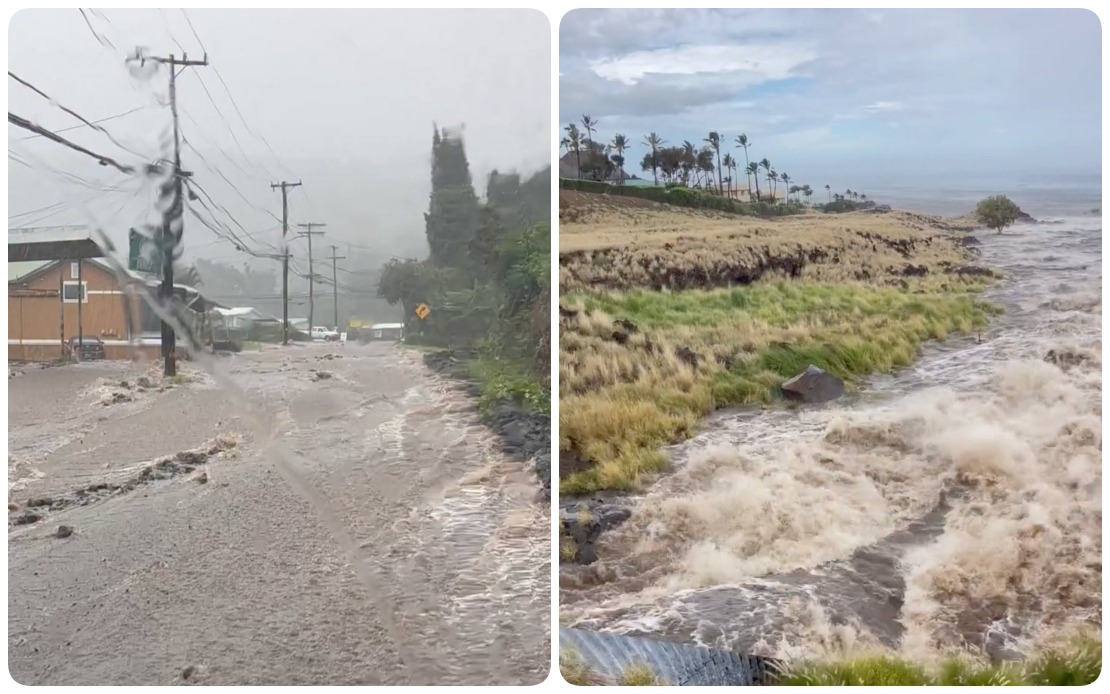
Hurricane Lala delivered a punishing blow to Hawaii's islands on Saturday, August 15, as it tracked just south of Hawaii Island with torrential rains and powerful winds that overwhelmed the archipelago's infrastructure. The storm's passage unleashed widespread damage and disruption across multiple islands, leaving more than 88,000 customers without electrical power and prompting emergency management officials to urge residents to shelter in place. The scale of the outages underscored the vulnerability of Hawaii's concentrated power systems when confronted with extreme tropical weather events.
Governor Josh Green documented the escalating severity of conditions across the Hawaiian islands as the hurricane's impact widened beyond its initial track. Hawaii Island experienced the brunt of the initial assault, with certain localities accumulating rainfall exceeding 13 inches within a compressed timeframe. As the storm's circulation broadened, deteriorating weather spread across Maui County, Oahu, and Kauai, indicating that no inhabited area escaped the hurricane's reach. The governor's observations reflected real-time monitoring of an unfolding natural disaster that threatened both immediate safety and longer-term recovery prospects for thousands of households.
The Hawaii Emergency Management Agency catalogued a constellation of destructive phenomena occurring simultaneously across the islands. Torrential downpours triggered flooding in low-lying areas and stream crossings, while sustained winds and isolated gusts toppled trees and compromised structures throughout populated zones. The combination of hydrological and wind hazards created compounding dangers that stretched emergency response capabilities and complicated efforts to assist stranded or isolated residents. Officials documented downed power lines as secondary consequences of wind damage, creating additional hazards beyond the original storm impact.
Hawaiian Electric's outage data revealed the geographic concentration and severity of the power disruption. Hawaii Island absorbed the most significant losses, with 63,270 customers losing electricity, representing the overwhelming majority of the statewide total. Maui County experienced approximately 15,260 outages, while Oahu recorded roughly 9,500 disconnections as of 7 p.m. Hawaiian Standard Time. The disparity reflected Hawaii Island's direct exposure to the storm's core, though significant populations on neighboring islands also faced extended darkness and loss of essential services dependent on electrical supply.
Video documentation from Hawaii's Department of Transportation illustrated the magnitude of hydrological impacts in real time. Recorded footage captured streams and waterways overflowing their banks, with roadways transformed into temporary channels carrying floodwaters across transportation corridors. The imagery conveyed both the immediate danger posed to motorists and the broader challenge facing infrastructure maintenance crews tasked with reopening routes once conditions stabilized. The visual evidence provided concrete illustration of meteorological projections manifesting as tangible infrastructure stress.
Road closures cascaded across three major islands as emergency officials implemented access restrictions to protect public safety. Hawaii Island experienced the most extensive network of closures, though Maui and Oahu also implemented traffic diversions and shelter-in-place orders. Specific incidents included flooding that rendered Kahikopele Street impassable in Mountain View and compromised Pauahi Street's utility, while Mamalahoa Highway faced warnings related to fallen trees and large debris littering the roadway. Downed power lines forced closure of additional corridors including Plumeria Street, compounding transportation chaos across the affected region.
Wind velocity measurements taken during the storm's passage revealed extreme conditions in specific microclimates across Hawaii Island. Meteorological stations recorded wind gusts approaching 90 miles per hour in particular locations, generating forces sufficient to fell mature trees and compromise wooden utility pole structures. The sustained violence of these winds along the Hamakua coast proved particularly destructive, with fallen vegetation bringing down multiple transmission poles and compromising electrical infrastructure across a 42-mile stretch of transmission lines. This linear damage corridor illustrated how topographical features can concentrate hurricane-force winds and amplify destructive impacts across specific geographic zones.
The vulnerability of Hawaii's electrical infrastructure to tropical cyclone impacts became evident as Hawaiian Electric confronted restoration challenges extending beyond the immediate storm period. The utility projected that customers already disconnected from power on Hawaii Island and Maui would remain without electricity through at least the following night and potentially longer. Dangerous ongoing weather conditions, including residual wind gusts and flooding risks, hampered crews' ability to safely conduct repair work on damaged poles, transmission lines, and distribution systems. The extended timeline for restoration highlighted how tropical weather events can paralyze recovery efforts even after the storm center departs.
For Malaysian and Southeast Asian observers, Hurricane Lala's impact carries implications regarding regional preparedness for extreme weather intensification. Hawaii's experience demonstrates how even developed infrastructure systems face significant vulnerabilities when confronted with concentrated tropical cyclone impacts. The storm's power disruption affecting nearly 90,000 customers illustrates how climate volatility can overwhelm distributed electrical grids, a concern particularly relevant for island economies and archipelagic nations across Southeast Asia. The extended restoration timelines documented during Lala's aftermath suggest that even wealthy jurisdictions with advanced technical capabilities require days to fully restore services after major tropical cyclone events.
The incident underscores broader questions about infrastructure resilience in tropical regions facing changing meteorological patterns. Hawaii's experience with back-to-back impacts from tropical cyclones has prompted discussion about hardening critical systems, implementing distributed renewable generation, and developing microgrids capable of functioning independently during grid-wide outages. These considerations resonate across Southeast Asia, where rapid economic development has concentrated populations and critical infrastructure in hurricane and typhoon-prone coastal zones. The recovery challenges documented in Hawaii provide a cautionary case study for regional planners evaluating long-term climate adaptation strategies and infrastructure investment priorities.

