Japan's meteorological authorities issued urgent warnings on Friday as the nation braced for the simultaneous arrival of two major typhoons threatening to unleash destructive winds and torrential rainfall across multiple regions over the coming weekend. The Japan Meteorological Agency alerted the public that Typhoon Higos was advancing from the Pacific Ocean and would likely make landfall within hours, while a second system, Typhoon Mekkhala, was already battering the southwestern Amami region in Kagoshima Prefecture with expectations it would shift toward the densely populated Kanto region the following day.
The dual typhoon threat has prompted extraordinary defensive measures across Japan. The Fire and Disaster Management Agency reported that as of Friday morning, more than 2 million residents spread across 13 prefectures spanning the Kinki and Kyushu regions had been placed under mandatory evacuation orders. The sheer scale of the displacement reflects the severity of the meteorological conditions and demonstrates how Japan's disaster response mechanisms mobilize swiftly when multiple natural hazards threaten simultaneously. In Seika, Kyoto Prefecture, local authorities issued the highest level 5 emergency safety alert for specific areas after a destructive landslide struck the town during Friday morning, signalling the immediate dangers already materializing from the approaching weather systems.
The rainfall preceding the typhoons' landfall has already reached alarming levels across vulnerable regions. Between Tuesday and Friday morning, Goto in Nagasaki Prefecture accumulated 600 millimetres of precipitation, while Aso in Kumamoto Prefecture and Ureshino in Saga Prefecture each recorded more than 500 millimetres. These extreme accumulations—equivalent to several weeks' worth of normal rainfall compressed into days—saturated soil and groundwater across southwestern Japan, creating ideal conditions for landslides and flooding even before the main typhoon systems arrive. The Japan Meteorological Agency expects such dangerous conditions to persist and intensify as the two typhoons approach populated areas.
Meteorologists anticipate that both Typhoon Higos and Typhoon Mekkhala will weaken as they transition into extratropical cyclones upon making landfall, a process that typically reduces wind speeds but does not necessarily diminish rainfall intensity or flood risks. The agency has specifically cautioned the public to remain vigilant against secondary disasters including landslides, flooding, and localized inundation, which often prove more destructive than initial wind impacts. The concern reflects Japan's experience with typhoon-related catastrophes, where heavy precipitation rather than extreme winds frequently causes the greatest loss of life and property damage.
As Typhoon Higos advances northward off Japan's southern coast, precipitation is forecast to intensify substantially across the Tokai and Kanto regions, continuing through Saturday. The Japan Meteorological Agency projects that the Tokai region could receive up to 300 millimetres of rain by Saturday noon, while the Kanto-Koshin region is expected to experience up to 150 millimetres. These projections compound the risk in the Kanto region, which already faces potential impact from Typhoon Mekkhala as it shifts eastward. The overlapping threat zones mean that some areas could experience successive heavy rainfall events, overwhelming drainage infrastructure and multiplying flood risks exponentially.
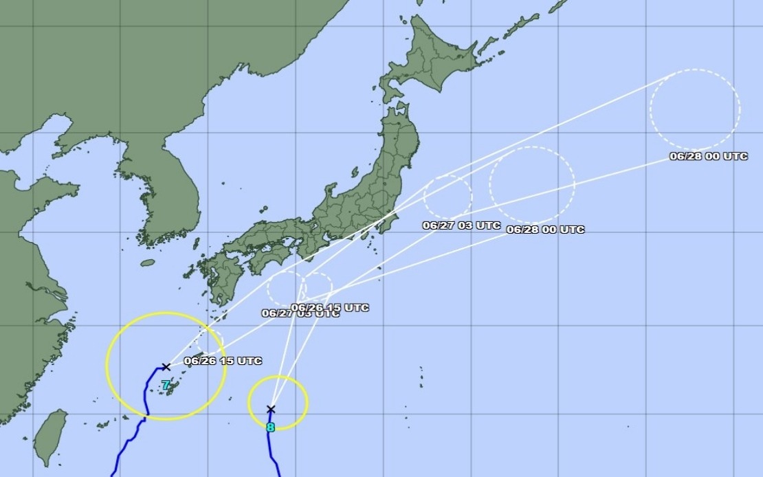
Tracking data as of Friday morning indicated that Typhoon Mekkhala was moving northeastward at a relatively modest speed of 15 kilometres per hour while positioned off the coast near Okinawa's Kume Island. The slower-than-typical movement speed raises concerns about rainfall duration and accumulation potential, as slower-moving systems tend to produce more total precipitation over a given area. Japan's island geography and topography, characterized by steep mountainous terrain and narrow coastal plains, render communities particularly vulnerable to flooding and landslide hazards when such slow-moving systems deliver sustained heavy precipitation.
The simultaneous approach of two significant typhoons presents an unusual challenge for Japan's disaster management infrastructure. Typically, emergency response resources concentrate on a single event, but the current scenario requires authorities to distribute evacuation capacity, shelter provisions, rescue personnel, and medical resources across multiple threatened zones simultaneously. The coordination between national agencies like the Fire and Disaster Management Agency and prefectural authorities has become critical to ensuring that evacuation orders are executed smoothly and that vulnerable populations including elderly residents and those with mobility limitations receive adequate assistance.
For Malaysian and Southeast Asian observers, Japan's typhoon preparedness demonstrates sophisticated early-warning systems and institutional responses that neighbouring countries continue developing. While the Philippines and other Southeast Asian nations experience typhoons with similar frequency, the institutional capacity to evacuate millions of people safely and to issue precise rainfall forecasts represents an investment in meteorological infrastructure that remains aspirational for many developing economies in the region. The economic costs of such disasters—including disrupted supply chains that affect regional trade—underscore why Japan and other developed nations prioritize weather prediction and disaster preparedness.
The environmental context amplifies current risks. Recent climate research indicates that warming oceans are intensifying tropical cyclones globally, and the western Pacific basin where these systems originate has experienced particularly pronounced warming trends. Japan's experience with increasingly intense typhoons has prompted investments in improved forecasting technology and updated building codes designed to withstand more severe weather. The current dual-typhoon scenario tests these systems while providing data that informs ongoing refinements to disaster preparedness protocols.