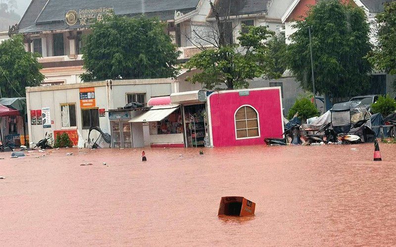
Authorities in Luang Namtha province, in the far north of Laos, have officially declared the region a disaster zone following catastrophic flash flooding that swept through the border area on Saturday, 29 August. The declaration came after torrential rains caused rapid rises in upstream river systems, sending surging waters southward across the provincial border and overwhelming communities, economic zones, and essential infrastructure across more than 30 villages. The flooding ravaged the Luang Namtha and Nalae districts particularly severely, though the international border checkpoint at Boten itself escaped major damage despite water levels rising perilously close to surrounding infrastructure.
The Luang Namtha Provincial Administrative Committee issued the formal disaster declaration in response to the scale of destruction caused by both the floods and associated landslides that destabilised hillsides throughout the affected districts. Water submerged numerous structures near riverine areas, including buildings at the Boten special economic zone—a crucial commercial hub for Laos-China trade—as well as an airport, multiple schools and health facilities. Agricultural land across vast stretches of the province lies under floodwaters, threatening harvests and the livelihoods of thousands of farming families who depend on the land for survival. Despite the extensive damage to surrounding areas, officials confirmed that the border crossing facility itself remained operational, a significant relief given the strategic importance of this gateway for bilateral trade and travel between Laos and Yunnan Province in China.
The immediate cause of the flooding lay in the exceptional volume of water cascading down from tributaries and main river channels feeding into the northern Laotian system. Following several consecutive days of intense rainfall across the region, water levels in upstream areas rose with alarming speed, creating a surge that overwhelmed the natural capacity of river channels to contain the flow. Hydrological monitoring stations recorded the severity of the situation with precision: the Tha River hydrology station measured water levels reaching 6.58 metres on the day of the worst flooding, comfortably surpassing the established 6-metre flood warning threshold and approaching the critical 7-metre level at which catastrophic flooding becomes inevitable. These measurements underscore the extraordinary nature of the weather event and the dangerous conditions that residents throughout the region have had to endure.
Weather forecasting officials from the Department of Meteorology and Hydrology, operating under the Ministry of Agriculture and Environment, issued formal flood warnings for the Tha River covering 29-30 August, giving authorities advance notice to prepare emergency responses. In response to the escalating danger, provincial administrators across five districts received urgent directives to mobilize local administrative structures and alert populations in high-risk zones—particularly those residing along riverbanks, in valley floors and other topographically vulnerable areas—to prepare for rapid evacuation should water levels continue their upward trajectory. The emphasis on preparation rather than panic reflected a measured official response designed to minimize casualties while ensuring communities had adequate time to move to higher ground with their valuables and essential possessions.
Provincial emergency management officials have implemented a comprehensive monitoring and reporting protocol to track conditions as they develop. Local authorities in affected areas must maintain constant surveillance of water levels, weather conditions and ground stability, while remaining primed to respond swiftly to any incidents—whether further flooding, landslide damage or structural collapses—that emerge in their jurisdictions. Detailed reporting requirements ensure that information flows continuously to provincial headquarters, enabling coordinated decision-making and resource allocation across the disaster zone. Television broadcasts and official announcements have kept the public informed of these safety measures and the critical importance of heeding official warnings.
The flooding in Luang Namtha represents merely the most severe manifestation of a much broader weather system affecting a substantially larger territory. A deep low-pressure system traversing northern Laos and adjacent southwestern China has triggered warnings across fourteen provinces, extending well beyond the immediate disaster zone. The meteorological disturbance, amplified by the southwesterly monsoon winds that characterise the region during this season, is expected to generate widespread scattered thunderstorms punctuated by periods of moderate to heavy rainfall and powerful winds persisting through the weekend. The combination of atmospheric conditions creates an environment where flash flooding and sudden landslides represent genuine threats to communities across a vast swath of territory.
Provincial authorities and weather services have identified an extended list of jurisdictions requiring heightened vigilance and emergency preparedness. Beyond Luang Namtha itself, the provinces of Phongsaly, Huaphan, Luang Prabang, Oudomxay, Xaysomboun, Bolikhamxay, Khammuan, Savannakhet, Salavan, Xekong, Champasak, Attapeu and even Vientiane capital face significant flood and landslide risks as the weather system progresses. This geographic span reflects the scale of the meteorological disturbance and underscores that Laos faces not a localized emergency but a multi-provincial crisis requiring coordinated national response and resource mobilization.
For residents across the affected regions, especially those in exposed locations near waterways or on unstable terrain, authorities have issued clear guidance emphasizing the importance of situational awareness and proactive preparation. Citizens are urged to maintain constant attention to weather forecasts and hydrological updates, to avoid unnecessary travel in dangerous conditions, and to position themselves and their families to respond quickly should evacuation become necessary. The messaging reflects official recognition that community preparedness and individual decision-making represent critical layers of protection when rapid natural disasters strike in areas where infrastructure and emergency services may become overwhelmed by the scale of the emergency.
The flooding crisis in Luang Namtha carries implications extending beyond immediate humanitarian concerns to encompass regional stability and economic considerations. The Boten special economic zone represents a critical node in Laos-China economic integration, facilitating trade flows and investment between the two nations. While the border crossing itself escaped major damage, the flooding has disrupted surrounding economic activity and transportation networks, potentially affecting bilateral commerce and the movement of goods across the frontier. Regional observers will monitor not only the humanitarian recovery phase but also the pace at which commercial activity resumes and economic linkages are restored.
For Southeast Asia more broadly, the flooding underscores the vulnerability of lower Mekong Basin nations to extreme weather events intensified by climate variability. Laos, with its predominantly mountainous terrain and extensive river systems, faces particular exposure to flash flooding and landslide hazards when monsoon weather systems deliver exceptional rainfall. The disaster in Luang Namtha represents a reminder of the region's environmental challenges and the necessity for improved early warning systems, infrastructure resilience and cross-border coordination mechanisms to manage transnational water resources and mitigate shared natural disaster risks. As climate patterns continue their evolution, such severe weather events may become more frequent, placing increasing demands on national and regional emergency management capacity.

