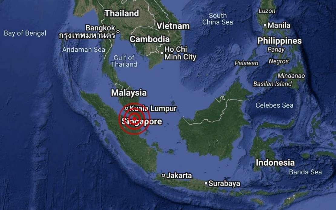
A weak earthquake with a magnitude of 3.1 was recorded off the coast of Batu Pahat in Johor on August 25, occurring at 4.12 pm local time. The tremor's epicentre was positioned at coordinates 1.7 degrees north and 102.8 degrees east, situated roughly 18 kilometres to the southwest of Batu Pahat town itself, placing it well within Malaysian waters in the Johor Strait region.
The Malaysian Meteorological Department, known locally as MetMalaysia, issued an official statement through its National Weather and Earthquake Operations Centre confirming the seismic event. The agency's rapid assessment and public notification reflected its standard protocols for monitoring and reporting earthquake activity across the country's maritime zones and populated areas.
Malaysia's earthquake monitoring capabilities have expanded significantly over the past decade, with MetMalaysia maintaining a sophisticated network of seismographic stations distributed throughout the peninsula and across Malaysian territories in Borneo. The Johor Strait region, despite its relative proximity to the Malaysian coastline, remains an area of seismic monitoring interest due to its position along broader fault systems that extend through the Southeast Asian region.
One of the most reassuring conclusions from the meteorological department was its immediate declaration that no tsunami risk existed for Malaysia following this seismic event. Tsunami generation typically requires earthquakes of considerably greater magnitude, usually exceeding 6.5 on the Richter scale, particularly when epicentres occur in shallow offshore waters. The 3.1-magnitude classification placed this tremor firmly in the category of minor seismic events that residents would likely not perceive, though sensitive instruments detected and recorded it.
Seismic activity in Malaysian waters, while not uncommon, generally remains modest in scale compared to zones lying closer to the Pacific Ring of Fire or the more tectonically active regions of Indonesia and the Philippines. The Johor Strait and its surrounding waters experience occasional tremors driven by tectonic adjustments along regional fault lines, yet these events rarely pose direct threats to infrastructure or populated centres on the Malaysian mainland.
For residents in Batu Pahat and surrounding Johor districts, such minor offshore earthquakes typically go unnoticed in daily life. The coastal town, situated on the western coast of Peninsular Malaysia facing the Strait of Malacca, represents one of Johor's historically significant maritime communities. Any seismic activity in proximate waters falls within normal geological processes that characterise the region's tectonic environment.
The rapid dissemination of earthquake information by MetMalaysia serves a critical public communication function, particularly given the region's volcanic and seismic history across the wider Southeast Asian context. Although Malaysia itself lies outside the most hazardous zones, neighbouring countries including Indonesia and the Philippines experience frequent and sometimes severe seismic events. Malaysian authorities maintain vigilance and readiness to communicate potential cross-border impacts, should they arise from larger regional earthquakes.
The August 25 event underscored the continuous work performed by Malaysia's meteorological and geological monitoring agencies in maintaining public safety awareness. Even minor tremors documented and reported contribute to the broader scientific understanding of regional tectonic patterns and fault systems. This data accumulation over years and decades helps researchers refine risk assessments and improve predictive modelling for future seismic scenarios.
From a regional perspective, Malaysia's relative seismic stability compared to neighbouring Indonesia and the Philippines represents both a geographical advantage and a source of lower public awareness regarding earthquake preparedness. The contrast with neighbouring nations experiencing more frequent and intense seismic activity means Malaysian communities and infrastructure planning systems receive less urgent impetus to prioritise earthquake resilience in the same manner as their counterparts across the strait.
The confirmation of no tsunami threat carried particular significance for Malaysia's maritime industries and coastal communities, whose economic activities and livelihoods depend on stable sea conditions. Fishing communities, shipping operations, and port facilities throughout Johor could proceed without concerns about unexpected oceanic disturbances generated by the minor tremor. Such reassurance matters considerably in maritime sectors where sudden changes in sea state pose genuine operational and safety challenges.
MetMalaysia's statement exemplified the transparent approach Malaysian authorities typically adopt when communicating scientific findings to the public. Providing specific coordinates, precise timing, and clear risk assessment enabled residents and stakeholders to understand the event's limited impact. This transparency builds public confidence in official channels and encourages citizens to trust authoritative scientific sources rather than relying on rumour or social media speculation during potential natural disasters.

