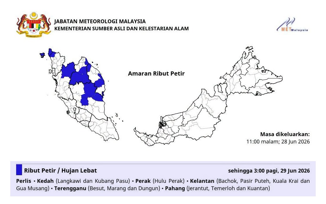
The Malaysian Meteorological Department issued an urgent weather alert on June 28 covering six states across the northern and east coast regions, warning residents and authorities to prepare for potentially dangerous atmospheric conditions lasting until 3 am the following day. The alert encompasses multiple administrative divisions within each affected state, suggesting a broad weather system rather than isolated localized disturbances affecting the peninsula.
Perlis has been included in the alert zone, while neighbouring Kedah faces warnings specifically in the districts of Langkawi and Kubang Pasu. The inclusion of Langkawi, a major tourism destination and the country's only duty-free zone, carries particular significance given the potential disruption to international visitor movements and commercial activities during the peak travel season. Perak's Hulu Perak region in the northern interior also faces heightened risk from the approaching system.
Kelantan has been identified as experiencing the most extensive coverage, with warnings affecting four separate districts: Bachok, Pasir Puteh, Kuala Krai and Gua Musang. This geographical spread indicates substantial atmospheric moisture and instability across the state, which typically experiences monsoonal influences. The breadth of coverage across these diverse terrain types—ranging from coastal zones to inland mountainous areas—suggests the weather system possesses considerable vertical development and horizontal extent.
Terengganu's coastal and interior zones, specifically Besut, Marang and Dungun, have similarly been placed under alert status. These regions represent a mix of fishing communities and industrial zones dependent on maritime activities, making the forecasted strong winds a particular concern for maritime safety and economic operations. The fact that three distinct districts within a relatively compact state require warnings demonstrates the intensity and spatial organization of the incoming weather pattern.
Pahang rounds out the alert zone with warnings issued for Jerantut, Temerloh and Kuantan. This coverage spans the state from its northwestern interior through its central regions to the coastal capital, indicating widespread atmospheric instability affecting different landforms and population densities simultaneously. Kuantan's inclusion is noteworthy as the state capital and a major port facility, underscoring potential impacts on commercial shipping and port operations during the warning period.
The temporal constraint of the warning—lasting until 3 am—suggests MetMalaysia expects the system to weaken or move beyond the warning zone by early morning. However, the specific targeting of this overnight window carries implications for emergency response services, transportation networks operating during night hours, and residents in vulnerable areas. Thunderstorms during overnight hours present particular hazards as visibility decreases and emergency services face reduced operational capacity.
The heavy rain component of the warning carries flood risk implications across the affected regions. Given that several of these states lie within flood-prone watersheds and that Pahang and Kelantan have experienced significant flooding in recent years, the timing and intensity of rainfall during this period warrant close monitoring by relevant water management and civil defence authorities. The confluence of thunderstorms with heavy precipitation multiplies hazard complexity.
Strong winds accompanying thunderstorms pose secondary hazards including potential structural damage to buildings, disruption of utilities, and dangers to maritime vessels. For states like Terengganu and Kelantan with significant fishing industries, wind warnings carry economic consequences as fishing fleets must remain in port, affecting food supply chains and community incomes. The combination of three distinct weather hazards—thunder, rain and wind—within a single warning system indicates a well-organized convective system rather than scattered isolated cells.
For residents and travelers across the warning zone, MetMalaysia's alert serves as a precautionary signal to secure outdoor items, avoid unnecessary travel during peak warning hours, and remain informed through official channels. The specific geographical detail provided by district-level warnings allows local authorities and community leaders to implement targeted preparedness measures rather than responding to vague regional alerts.
The warning reflects the peninsula's vulnerability during this monsoon transitional period, when atmospheric conditions can shift rapidly. For Malaysian businesses, particularly those in tourism, logistics and maritime sectors operating within the affected areas, such alerts necessitate contingency planning and real-time operational adjustments. The six-state coverage demonstrates that weather systems affecting Malaysia's peninsula can achieve significant geographical scope and intensity, requiring coordinated response mechanisms across multiple state administrations and federal agencies responsible for disaster management and public safety.