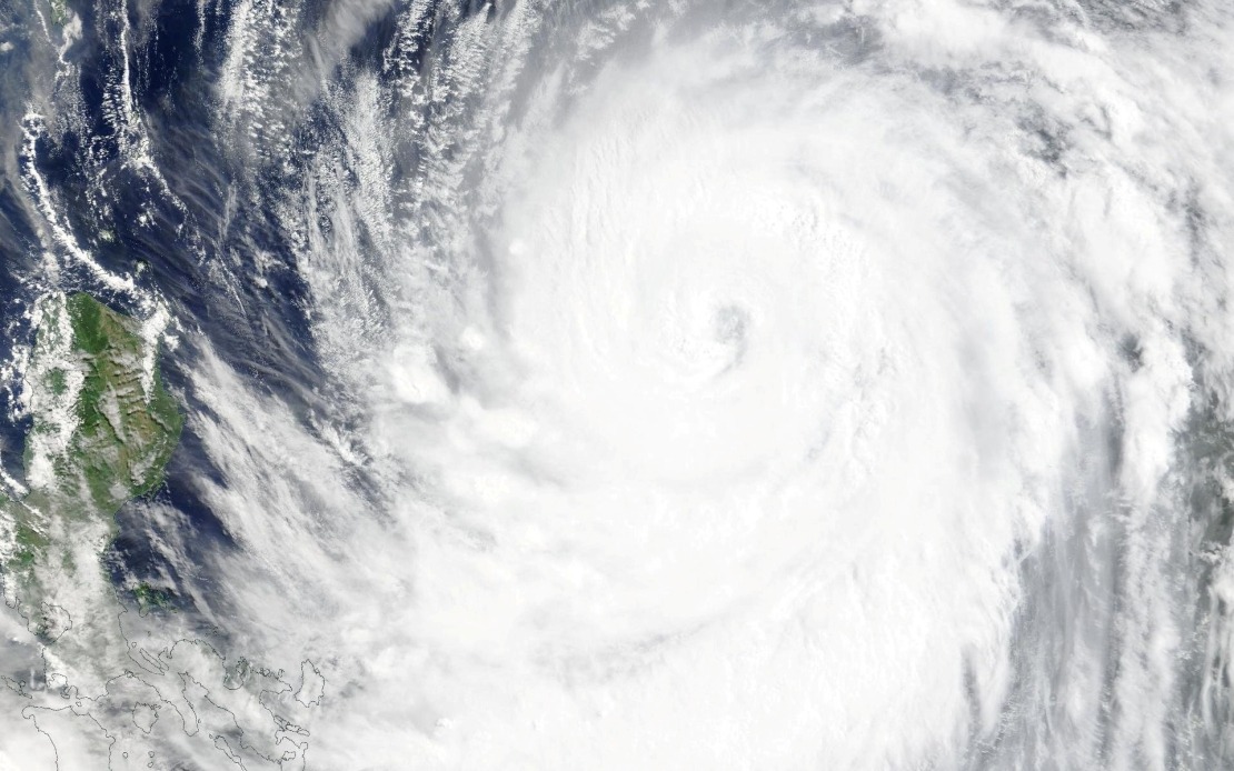
Taiwan's Central Weather Bureau escalated its alert status on Thursday afternoon as Typhoon Bavi, the ninth major tropical cyclone of the year, drew closer to the island nation with strengthening intensity. The weather authority activated a sea warning at 2.30 pm, directing the precaution across critical maritime zones including the waters surrounding Orchid Island and Green Island off Taiwan's eastern coast, as well as the strategically important Bashi Channel that separates Taiwan from the Philippines. Officials flagged that a more comprehensive land warning for the main island would likely be issued within hours as the system continued its northwestward trajectory.
At the time of the announcement, Typhoon Bavi maintained a position to the southeast of Eluanbi, Taiwan's southernmost geographic point, while tracking persistently toward the northwest. Meteorological measurements indicated the storm possessed maximum sustained winds of 51 metres per second in its immediate vicinity, with peak gusts accelerating to 63 metres per second—wind speeds capable of inflicting substantial structural damage and creating hazardous conditions across exposed terrain. These measurements placed Bavi among the more formidable tropical systems to threaten the Taiwan region during the monsoon season.
Weather forecasters projected that Typhoon Bavi would maintain its northwest movement at a measured pace of 15 to 20 kilometres per hour, positioning it on a trajectory that would carry the storm's core across or just beyond Taiwan's northern reaches. Rather than a direct overhead passage, the anticipated path suggested that Taiwan would experience the typhoon's outer bands and peripheral effects, though meteorologists cautioned the impact would nonetheless register as a significant weather event. The island faced the prospect of encountering either a lower-tier severe typhoon or an upper-category moderate typhoon, depending on subtle variations in the storm's precise track and final intensity at landfall.
The approaching cyclone has already generated tangible disruptions across the transportation network connecting Taiwan to neighbouring regions. Most commercial flight operations between Taiwan and Okinawa in Japan's southern Ryukyu Islands chain have been suspended by carriers exercising precautionary measures. Beyond East Asian connections, several longer-distance international services extending to more distant destinations have similarly been cancelled or substantially rescheduled as airlines adjust operations in anticipation of deteriorating conditions. This reflects the conservative but prudent approach adopted by carriers when major weather systems threaten established flight corridors.
Maritime transport has likewise felt the immediate consequences of the storm's approach. Ferry operators connecting Taiwan with outlying islands and neighbouring territories announced the suspension of multiple established routes, prioritising passenger safety over maintaining schedules. Simultaneously, authorities managing Taiwan's extensive mountain road network issued formal alerts regarding hazardous driving conditions, effectively discouraging non-essential travel through elevated terrain where typhoon-force winds and heavy precipitation pose acute risks to vehicular safety. These coordinated transportation restrictions represent standard emergency protocol designed to minimise exposure to dangerous conditions.
For Malaysia and Southeast Asia more broadly, the situation underscores the region's vulnerability to the Western Pacific typhoon system, which generates powerful cyclones that occasionally affect Malaysian territories and maritime zones. The Bashi Channel through which Typhoon Bavi's circulation extended sits along crucial shipping lanes connecting East Asian ports to Southeast Asian commercial hubs, making weather disruptions in this corridor significant for regional logistics. Malaysian maritime authorities and shipping operators typically monitor intense Western Pacific typhoons closely, as they can influence weather patterns and sea conditions affecting regional waters and shipping schedules.
Typhoon Bavi's development and intensification also reflect broader atmospheric patterns characteristic of the Northwest Pacific's peak cyclone season from July through September. During these months, warm ocean temperatures and favourable wind shear conditions create an environment conducive to rapid storm formation and intensification. Taiwan, positioned directly along the primary typhoon track for systems developing in the warm waters east of the Philippines, routinely faces direct or near-miss encounters with major cyclones during this seasonal window. The preparedness systems that Taiwan has developed, illustrated by the methodical warning protocols activated for Bavi, represent the accumulated experience of an island nation in the path of the Pacific's most active typhoon-genesis region.
The disruption triggered by Typhoon Bavi demonstrates the vulnerability of modern supply chains and transportation networks to atmospheric hazards despite technological advances in forecasting and infrastructure hardening. Tropical cyclones moving through densely interconnected transportation hubs create cascading effects across commerce, logistics, and personal travel plans. For businesses operating across the Taiwan Strait and throughout the broader region, such disruptions necessitate contingency planning and inventory management strategies that account for the recurring seasonal risk of typhoon-related shutdowns and service interruptions.
Taiwan's meteorological authority maintained continuous monitoring of Typhoon Bavi's evolution, with updated guidance expected as the system approached the island. The progression from sea warning to land warning represented the standard operational sequence, allowing authorities time to coordinate emergency response resources, alert residents to potential hazards, and ensure that critical infrastructure and utilities were positioned to withstand the approaching weather. Such proactive communication reflects established best practices in public safety management that have been refined through decades of direct typhoon experience on the island.

