Arsenio Butil Jr., a fisherman and pastor in Glan, Sarangani province, fell to his knees in prayer when the earthquake struck his coastal home last week. As the violent shaking subsided and he opened his eyes, he witnessed something few people ever experience: the shoreline transforming before him in real time. What had once been the familiar water's edge was now revealing vast expanses of previously submerged coral, thrust upward by forces deep beneath the earth's crust.
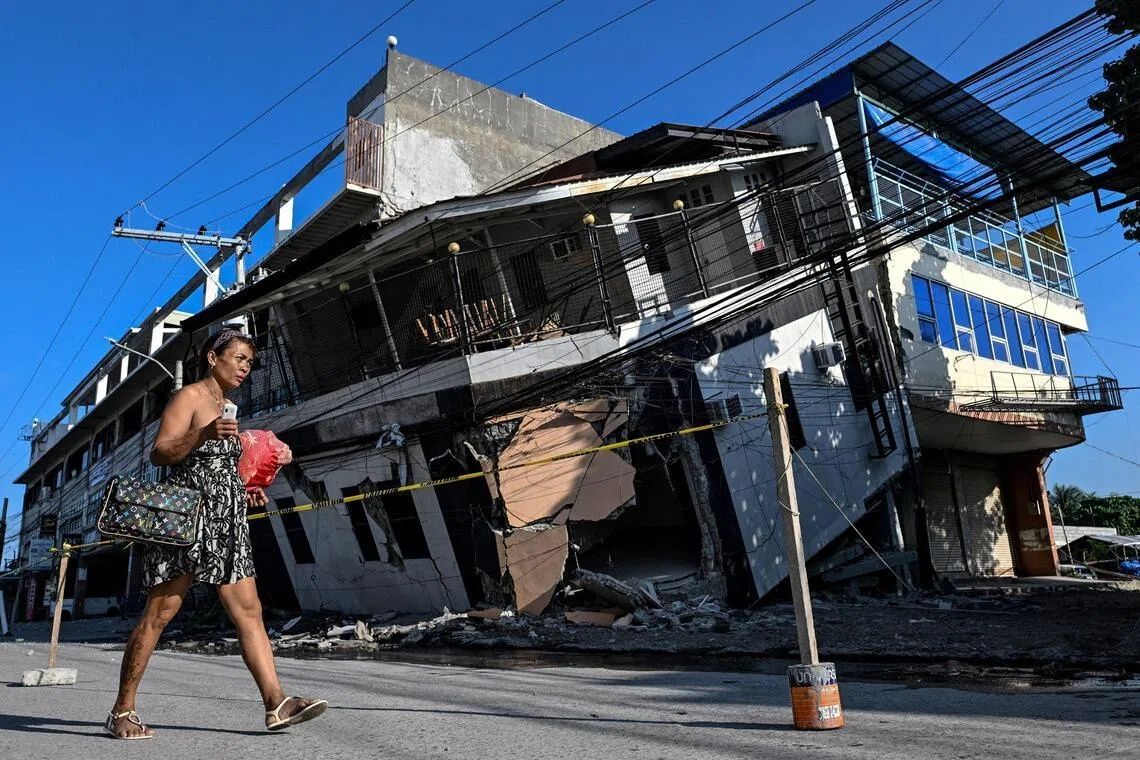
The 7.8-magnitude earthquake on June 8 originated from movement along the nearby Cotabato Trench and proved catastrophic in its conventional impacts. The tremor toppled buildings across Mindanao, triggered devastating landslides, and killed at least 76 people. Yet beyond the immediate destruction lay a geological phenomenon that would permanently alter the landscape and the lives of those who depended on it. The same tectonic forces that devastated communities also initiated what geologists call coastal uplift, a process that fundamentally changed the geography of stretches of the island's coastline.
AFP reporters visiting the affected region encountered a surreal landscape: fishing boats that once sat at the water's edge were now marooned on the wrong side of a jagged wall of exposed, newly dead coral that stretched for kilometres in both directions. The transformation was so dramatic that families who had spent their entire lives along these shores no longer recognized their own coastline. Butil Jr. described the earthquake as the most powerful he had ever experienced, noting how the water receded and returned multiple times during the violent shaking. "The fish were dying and floating," he recounted, capturing the ecological chaos that accompanied the geological upheaval.
The Cotabato Trench, positioned as close as 50 kilometres off the coast of Mindanao, has long been recognized as a zone of significant seismic activity. In January, the region experienced a "swarm" of thousands of tremors, mostly minor in magnitude. A United Nations disaster risk reduction report released in mid-May had warned that such seismic swarms could potentially precede a major earthquake. The June 8 event appeared to confirm those concerns, though the scale of coastal change it produced surprised many observers.
According to Nane Danlag, a seismologist at the Philippines' seismology centre, the transformation was both dramatic and permanent. The seabed rose approximately two metres during the earthquake, extending the shoreline by up to 200 metres in certain areas based on initial assessments. Danlag explained that the affected zone stretched between two towns nearly 100 kilometres apart, making this one of the more extensive coastal uplift events recorded in recent times. She emphasized that what residents now see is their permanent new coastline, characterizing the shift as a natural process that has been occurring on geological timescales for thousands of years.
The human toll of this geological upheaval extended far beyond immediate casualties. About 100 residents, including fishermen and their families, remained encamped in the hills above a neighbouring village during the AFP visit, having fled to higher ground when the earthquake struck. Datu Atom Malimpnig, a Maguindanaon chieftain, explained that the newly formed coastline had made the group reluctant to return to their destroyed homes. Despite government aid workers providing rice porridge to evacuees, fear persisted among the community. Malimpnig articulated the deep anxiety that gripped many: the fear that the sea, having receded so dramatically, might surge forward unpredictably in a tsunami. For these displaced residents, the hilltop encampment felt infinitely safer than returning to homes where the earth itself seemed untrustworthy.
The economic implications of the coastal transformation extended beyond immediate humanitarian concerns to affect the broader regional economy. Ten kilometres from the evacuation site, Edzel Baylon, a staff member at the Isla Jardin del Mar resort, described the consequences for a tourism destination that had marketed itself on white sand beaches and ocean access. The newly exposed coral separated the once-idyllic beachfront from the water, rendering the shallow new seascape unsuitable for swimming and fundamentally altering the resort's appeal to holiday-seeking customers. The transformation that geologists view as a natural process had become, for the tourism industry, an economic catastrophe.
The seismic activity continued unabated in the weeks following the major earthquake. Official records indicated that more than 8,500 aftershocks had shaken the region since June 8, a relentless reminder of the unstable conditions persisting beneath the surface. This ongoing activity heightened community anxiety and complicated recovery efforts. In Glan, residents remained reluctant to attempt rebuilding their destroyed homes, with Butil Jr. noting the extensive ground fissures that crisscrossed the area. He warned that another earthquake of comparable magnitude could prove catastrophic, particularly given the compromised structural integrity of the earth itself. Even as conversations turned to reconstruction, the visible damage to the ground served as a stark reminder of the forces at work.
For Malaysia and other Southeast Asian nations, the Philippine earthquake offers important lessons about seismic risk and coastal vulnerability. The region sits along the Pacific Ring of Fire, where multiple tectonic plates interact and generate significant earthquake activity. The phenomenon of coastal uplift, while dramatic, also demonstrates how rapid geological change can disrupt not only human settlements but also entire ecosystems and economic sectors dependent on stable coastal geography. The displacement of entire communities and the transformation of familiar landscapes underscore the importance of robust disaster preparedness, early warning systems, and longer-term planning for areas susceptible to major seismic events.
The psychological and social dimensions of the disaster extended beyond physical displacement. Communities that had maintained continuity with ancestral lands and livelihoods for generations suddenly found themselves in an unfamiliar landscape. The fear of further disasters, combined with the loss of homes and economic activities, created a compound trauma that extended well beyond the immediate aftermath of the earthquake. Butil Jr. and others in his community faced the prospect of rebuilding not just their homes but their entire relationship with the land and sea that sustained them, now fundamentally altered by forces beyond human control.